Safe cruising in the Inside Passage means having the right charts, but this can be confusing and expensive. You have to know which charts and how much detail you think you need. Do you want electronic only or will you carry paper charts? For your electronic charts, which software will you use, and do you want vector or raster, or both?
On the David B, we’ve made the following choices: We carry all the paper charts, all the electronic charts, and we use a laptop-based plotter to view the electronic ones. You can outfit you boat with either a laptop based plotter or a stand-alone plotter like a Furuno, Raymarine or Garmin. Since we use a laptop, I’ll be focusing on this type of plotter system.
Paper Charts:
On the David B we carry both paper and electronic charts. You might ask why we still carry a complete set of paper charts for the Inside Passage, when we could save the space and have only electronic charts? It’s because paper does not fail (unless it gets blown out a window or it’s dark and you can’t find a flashlight).
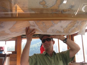
When we began to outfit the David B for cruising between Bellingham and Juneau, we knew we wanted to have a thorough set of paper charts that we could use as a back up in case our electronic program failed. We also wanted our passengers to look at a real paper chart. Since paper charts take up a lot of surface area, we built two glass bottom boxes in the pilothouse overhead that hold our charts flat. One box has a large scale chart that gives an overview of the landscape, and the other box shows a smaller area, but has more detail. We’ve found that it’s often easier to identify where we are to our passengers by reaching up and pointing to a spot on a paper chart, than it is to zoom out or change our chart view on the plotter.
Electronic Charts:
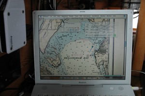
There are two types of electronic charts — raster and vector. Raster Navigational Charts (RNC) are scans of paper charts. The pros of using RNCs are that they are the same as paper charts, so you’ll feel familiar with them. The biggest drawback to the RNCs are that you can’t zoom in for more detailed information.
Vector based charts are known as ENCs or Electronic Navigational Charts. They store the information as data which means that you can choose which attributes (like soundings) you want to see on your screen and zoom to any level to see more. The drawback is that you can have too much information on your chart plotter and not see a marked hazard.
Software for Electronic Charts:
To use electronic charts you’ll need to pick a software program. Some systems are compatible with NOAAs and the Canadian Hydrological Service’s charts, while other systems rely on their own proprietary charts. We use GPSnavX on the mac, and have been very happy with Coastal Explorer from Rose Point Navigation on the PC. You’ll want to decide what works best for you. To see a list of companies that offer a wide range of options, visit: http://www.nauticalcharts.noaa.gov/mcd/enc/resource.htm
American Charts:
One of the great services mariners get from NOAA is the ability to download or print US electronic or paper charts free of charge. So,how do you decide which paper charts you’ll need? We chose to download the entire west coast of North America from NOAA because computers have so much hard drive space. To find the charts you’ll want you can visit NOAAs Online Chart Viewer to look at the charts for the areas you’re planning to cruise. Once you know which paper charts you’ll need, you’ll need to visit a marine store or order your charts online. NOAA has a list of places that sell traditional paper charts — http://www.nauticalcharts.noaa.gov/staff/charts.htm#paper.
Canadian Charts:
The Canadian Hydrological Service does not sell paper or electronic charts to the public and you’ll need to find a dealer. I recommend the complete set for the British Columbia coast on a CD/DVD. Their website has a chart finder and locater page to make your search easier. http://www.cartes.gc.ca/charts-cartes/index-en.gasp
Updating Charts:
Charts are dynamic and change, the only problem is that depending upon the type of charts that you use, you might have to correct the charts yourself. The US Coast Guard offers a Notice to Mariners service for chart updates. You can subscribe to the updates for specific districts. The Coast Guard district for Washington state is District 13 and Alaska is District 17. You’ll be emailed daily a list of changes.
The Canadians will let you choose which charts you want notification of changes. To receive a weekly email or to look at updates for specific charts you can go to their Notice to Mariners page.
We carry a lot of redundancies on the David B when it comes to navigation. We have paper charts, RNCs and ENCs. Each type of chart offers it’s pros and cons. Having a paper chart out keeps you familiar with your overall surroundings and it’s easy to quickly point to a spot on the chart without fiddling with your chart plotter. Paper charts are also an important backup in case of an electronics failure. Electronic charts are fantastic when used with GPS and AIS, but you run the risk of having too much information cluttering up your screen. For our electronic charts we like to keep it pretty simple. The information that we like to have is our track and what is available from the AIS. We mostly use the RNCs, but we can also switch to the ENCs. We also carry a spare GPS receiver for our chart plotter. We try to be as self-reliant as possible in the Inside Passage. There are many places where a failure could be inconvenient and dangerous. For us deciding to have three different kinds of charts might seem overkill, but in the end we know we’ll always have something that works.


I am bringing a 37′ Tolly up from Bellingham in June. Having never done this before, I am eager to learn all I can from folks like you. What, besides passports and boat documentation and safety gear, am I required to have in Canadian waters? Do I need to have an AIS system installed? I am collecting charts and I have two GPS units onboard, plus radar. Do I need tidal charts? Where is the best place to view tide charts? I am contacting your suggestion for Canadian charts.